LakeBiwaSB 2.1.0
 Prev
Prev
Top
Release Note
2.1.0 OS X 10.11に対応。サイトから情報取得できなかった不具合の修正。
1.1.0 AppSandbox 対応。
Description
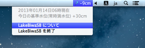
メニューバー(ステータスバー)に、琵琶湖の水位を表示するアプリケーションです。
国土交通省近畿地方整備局 琵琶湖河川事務所のサイトから琵琶湖の水位等データを取得、表示します。
ステータスバーには水位、メニュー項目には、データ取得日と基準水位を表示します。同サイトからデータを取得できない(インターネットに接続されていない)場合は、最後に取得したデータを表示します(その場合にはステータスバーのアイコンがモノクロ表示となります)。
なお、琵琶湖の水位は速報値であり、当日の朝6時の水位となっています。リアルタイムでデータ更新はしていません。
Download
LakeBiwaSB Download from App Store
Limitation of Liability
琵琶湖の水位データは、国土交通省近畿地方整備局 琵琶湖河川事務所の許可を得て使用しています。
このソフトウェアにより表示され、アクセスされるコンテンツの一切の所有権および知的財産権は、それぞれのコンテンツ所有者 に帰属します。これらのコンテンツは、著作権またはその他の知的財産権の法律もしくは条約に保護されることがあり、これらのコンテン ツを提供する第三者の使用条件に従っていただくことがあります。
作者iMappieは、この software に起因してご使用者に直接または間接的損害が生じてもいかなる責任を負わないものとし、一切の賠償等は行わないものとします。
作者iMappieは、この software に不具合、不備があっても程度の如何に関わらず訂正、改修する義務を負わないものとします。
Lake Biwa's waterlevel and related information provided by Biwako River Office (Kinki Regional Development Bureau in Ministry of Land, Infrastructure, Transport and Tourism) are used with permission.
Intellectual property rights in and to any content displayed by or accessed through the iMappie Software belongs to the respective content owner.
Such content may be protected by copyright or other intellectual property laws and treaties, and may be subject to terms of use of the third party providing such content.
Under no circumstances including negligence, shall iMappie be liable for any incidental, special or consequential damages that result from the use or inability to use the iMappie software or related documentation.
Prev
Top
2008-2016 iMappie All Rights Reserved.