Science 19 September 1997:
Vol. 277 no. 5333 pp. 1796-1799
DOI: 10.1126/science.277.5333.1796
Joe W. Saunders*,Rolfe D. Mandel,Roger T. Saucier,E. Thurman Allen,C. T. Hallmark,Jay K. Johnson,Edwin H. Jackson,Charles M. Allen,Gary L. Stringer,Douglas S. Frink,James K. Feathers,Stephen Williams,Kristen J. Gremillion,Malcolm F. Vidrine andReca Jones
Abstract
An 11-mound site in Louisiana predates other known mound complexes with
earthen enclosures in North America by 1900 years. Radiometric, luminescence,
artifactual, geomorphic, and pedogenic data date the site to over 5000
calendar years before present. Evidence suggests that the site was occupied
by hunter-gatherers who seasonally exploited aquatic resources and collected
plant species that later became the first domesticates in eastern North
America. Native American mounds have been recognized and studied in the eastern
United States for more than a century. They represent early evidence for
organized society in North America. Most of the earthen mounds and enclosures
in the east date to <2500 calendar years before present (B.P.) (1). In the 1950s, the recognition of preceramic mounds and earthen enclosures
from earlier times came first at the Poverty Point site in Louisiana, dating
to 3500 calendar years B.P. (2, 3). By the 1970s, four mound sites in Louisiana and one in Florida had been
dated to >5000 calendar years B.P. (Middle Archaic), but the data were
not conclusive and the antiquity of the sites remained in doubt (4, 5). In the 1990s, four additional mound sites in Louisiana (6, 7, 8) and two in Florida (8) have been identified as Middle Archaic in age. Collectively, the Middle
Archaic mound sites provide 56 radiometric dates that establish the antiquity
of earthen mounds in the southeast. Of these sites, Watson Brake in northeast Louisiana is the largest, most complex, and most securely
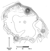
dated site. Its 11 mounds and connecting ridges form an oval-shaped earthen
enclosure 280 m in diameter (Fig.1). The largest mound (Gentry Mound) is 7.5 m high; the other mounds measure
between 4.5 and 1 m in height, and the connecting ridges average 1 m in
height. Here we present evidence that Watson Brake predates the large-scale earthworks of Poverty Point by 1900 years, making
it the earliest such human construction so far recognized in the New World.
Figure 1 Watson Brake topographic map. Black squares indicate test units. Test unit 5 is an
extension of test unit 4 in mound C; thus there are only seven squares
on the map. Contour interval = 0.5 m.
Watson Brake is constructed on the edge of a low, flat Pleistocene terrace (Mid-Wisconsin
stage) overlooking the Holocene floodplain (<12,000 calendar years B.P.)
of the Ouachita River (9,10). Before 7000 calendar years B.P. (10), meander belts formed by the paleo?Arkansas River provided gravel and
sand shoal channels in the Ouachita Valley, and swamp and small-stream
habitats formed in backwater areas near Watson Brake. These conditions persisted until about 4800 calendar years B.P., when
a diversion of the Arkansas River into the present course of the Ouachita
River caused rapid alluviation near Watson Brake (10), decreasing the extent of the swamp and small-stream habitats. This event
may coincide with abandonment of the site.
We verified the cultural origin of each mound and ridge with eight test
units and soil cores. Mounds and ridges along the edge of the Pleistocene
terrace were constructed in multiple stages and on premound or ridge middens
(11). Mounds and ridges set back from the terrace edge were constructed in
single stages and on the truncated Bt horizon of the Pleistocene terrace
(the A horizon was removed before mound or ridge construction). This removal
suggests that mound and ridge placement on the north and east sides followed
the natural topography, whereas mounds and ridges on the west and south
sides of the enclosure were placed to complete the enclosure. The extensive
weathering of fill in the single- and multiple-stage mounds and ridges
suggests that all of the earthen structures are contemporaneous. The physical, chemical, and morphological properties of soils that developed
in the mounds and ridges indicate that the earthen architecture is of great
antiquity. These soils are strongly weathered, with well-expressed A-E-Bt
horizonation (Ultisols and Alfisols). A typical profile consists of a 1-m
solum with a fine sandy loam ochric epipedon (A horizon), a fine sandy
loam to loamy fine sand albic (E) horizon, and a reddish, clay-enriched
argillic (Bt) horizon. The Bt horizons are 40 to 80 cm thick and have fine
and medium subangular-blocky structure. Clay translocation, which leads
to the development of the Bt horizons, is pronounced as indicated by (i)
clay depletion of the overlying A and E horizons, (ii) enrichment of the
Bt horizons in clay content relative to overlying horizons and underlying
unweathered mound fill, (iii) high ratios of fine clay to total clay in
the Bt horizons, and (iv) the presence of argillans (clay coatings) in
the Bt horizons. The argillans have variable thickness (100 to 300 μm)
and are composed of microlaminated clay. Extensive leaching is indicated
by low concentrations of exchangeable bases (Ca, Mg, Na, and K) and pH
of 5.1 to 3.9 to great depths. Base saturation ranges from 10 to 51% in
the Bt horizons. Iron has leached from the A and E horizons (0.3 to 0.5%)
and illuviated into the Bt horizons (0.9 to 1.1%). The strongly developed soils on the mounds and ridges at Watson Brake may
be partially attributed to the nature of the material used to construct
these features. Emplacement of weathered (preconditioned) material during
the final stage of mound and ridge construction would favor rapid pedogenesis.
However, the formation of thick Bt horizons that meet argillic criteria
is time-dependent because weathering, clay formation, and translocation
are slow processes (12). Hence, we suggest that the Ultisols and Alfisols developed in the mounds
and ridges are products of thousands of years of pedogenesis. We obtained 19 radiocarbon assays from buried A horizons on the premound
and preridge surfaces as well as from the surfaces of successive stages
of mound and ridge construction (Table1). Two of the dates are considered anomalous because of their younger-than-expected
age (13). Dates on four charcoal scatters from submound and subridge A horizons
(mounds A, B, and C; ridge K/A) range between 5880 and 5450 calibrated
(cal.) calendar years B.P. Dates for soil humates from two submound A horizons
(mounds A and D) are 5285 and 5450 cal. calendar years B.P. These dates
suggest that mound construction at Watson Brake began between 5400 and
5300 calendar years B.P.
Table 1 14C dates from Watson Brake. Rg, ridge; Md,mound.
Six charcoal samples from buried A horizons on successive stages of mound
B and stage I of ridge K/A yielded radiocarbon ages between 5590 and 5290
cal. calendar years B.P., and humates from four buried A horizons in mounds
A, C, and D range in age between 4870 and 4520 cal. calendar years B.P.
In addition, humates from a pit-hearth in the surface of stage I, mound
C dates to 4826 cal. calendar years B.P. On average, the humate ages are
700 years younger than the charcoal ages. The humate ages appear to be
too recent because of postburial input of organic carbon. Soil organics
are susceptible to contamination by modern rootlets, humic acids, and other
sources of young carbon, which can yield anomalously young radiocarbon
ages (14, 15).
Independent means of determining the antiquity of Watson Brake include
luminescence dating of mound and ridge sediments (16). We examined samples from the buried A horizons of stage I, mound B and
stage I, ridge K/A. It was hypothesized that the formation of A horizons
on the intermediate stages had provided adequate time for bleaching of
sediments through recycling to the surface by pedoturbation. Thermoluminescence
analysis of the slowly bleaching component in quartz produced geological
rather than archaeological ages, which suggests that bleaching was incomplete.
Optically stimulated luminescence (OSL) of the rapidly bleaching component
using single aliquot analysis (17) yielded an age of 4003 ± 444 calendar years B.P. for ridge K/A and a
maximum age of 5538 ± 936 calendar years B.P. for mound B. The OSL signal
for the ridge sample appeared well bleached in antiquity, but variation
in equivalent dose from aliquot to aliquot suggested that bleaching of
the mound B sample was incomplete. The mean residence time of three mounds and two ridge segments was calculated
with the experimental dating method of oxidizable carbon ratio (OCR). The
OCR procedure measures biochemical degradation of organic carbon within
the site-specific environmental context (18, 19). Analysis of 200 soil samples suggests that the submound soils were buried
with mound fill, thereby arresting biochemical degradation, at ?5180 ±
155 calendar years B.P. and that mound fill pedogenesis began at ?5010
± 150 calendar years B.P. Artifactual data support a pre?Poverty Point (>3500 years B.P.) origin
for the mounds and ridges. None of the Poverty Point archetypes (20, 21) have been recovered from Watson Brake. Projectile points from Watson
Brake are Middle to Late Archaic in age (22). Lithic material is local gravel, in contrast to Late Archaic and Poverty
Point sites, where nonlocal material is common (23, 24). Blade production at Watson Brake is casual, with minimal platform preparation
and no platform rejuvenation. At Poverty Point, blade cores have more formal
platform preparation and blade removal (25). Watson Brake blades frequently were transformed into microdrills for
bead production, averaging 9.9 by 2.7 by 2.2 mm. This technology is similar
to the Middle Archaic assemblages from east central Louisiana (26) as well as from the Keenan Cache (27) and the Slate Site (28) in Mississippi. Local gravel was used for cooking stones at Watson Brake. In addition,
fired earthen objects (function unknown) occur in a variety of undecorated
shapes (cuboidal, rectangular, spherical, and cylindrical); block forms
are the most common. Similar fired earthen objects have been recovered
from Frenchman's Bend Mounds, a Middle Archaic site 35 km northeast of
Watson Brake (7). There, mound deposits with fired earthen blocks date to 5570 (7) and 5290 cal. calendar years B.P. (β69637, 4560 ± 140 corrected, uncalibrated
14C years B.P., charcoal scatter), which is about the same age as that of
Watson Brake specimens. Undecorated blocks have not been found at Poverty
Point. Over 175,000 pieces of bone were recovered from mound B, stage I and its
submound surface. Aquatic species predominate and fish are the most abundant
food remains. Main channel species were preferred, including freshwater
drum (Sciaenidae), catfish (Ictaluridae), and suckers (Catostomidae). Additional
aquatic foods include 17 mussel species (Unionidae), one aquatic snail
(thousands ofCampeloma sp.), turtle, and duck. Deer, turkey, raccoon, opossum, squirrel, rabbit,
dog, and rodent remains also were recovered from the midden. Charred seeds from the same midden deposits represent three species of
the complex of weedy annuals (29). These include goosefoot (Chenopodium berlandieri), knotweed (Polygonum spp.), and possibly marshelder (Iva annua). The morphology of the goosefoot seeds is consistent with var. boscianum, a taxon uncommon in the area today. None of the seeds exhibit morphological
features associated with evolution under cultivation. However, their presence
may reflect the early development of ecological relationships that eventually
led to domestication. The fauna and flora suggest that Watson Brake was occupied seasonally.
Fish otoliths indicate that most fish were caught in spring to early summer
and fall. The spring to early summer peak probably corresponds with the
spawning of the freshwater drum (Aplodinotus grunniens). The plant species seed in the summer through fall, also suggesting seasonal
occupation of the site. Increases in terrestrial species coupled with decreases in mussel and slackwater
fish between the earlier premound midden and the later stage I midden of
mound B may reflect a change in the local environment. The decline in the
main channel, gravel/sand shoal habitats, backwater swamps, and small-stream
habitats near Watson Brake may have resulted in a shift from aquatic resources
to terrestrial species, eventually leading to site abandonment. Geomorphic, pedogenic, radiometric, luminescence, and artifactual data
have established the Middle Archaic age of Watson Brake. Faunal and floral
data show that the site was constructed and occupied by hunter-gatherers
who seasonally exploited riverine animals and plants. Planned large-scale
earthworks such as Watson Brake were previously considered to be beyond
the leadership and organizational skills of seasonally mobile hunter-gatherers.
Poverty Point was considered the exception, and its extensive trade was
cited as evidence for sophisticated socioeconomic organization (20). Our data imply that less complex mound building societies flourished
in the southeast more than 1900 years before Poverty Point. Furthermore,
not only did these Middle Archaic societies establish monumental architecture
in the southeast, but they also may have initiated ecological relationships
that led to the eventual domestication of weedy annuals in eastern North
America.
- Received for publication 27 May 1997.
- Accepted for publication 4 August 1997.
REFERENCES AND NOTES
- ?
B. D. Smith, in Advances In World Archaeology, F. Wendorf and A. Close, Eds. (Academic Press, New York, 1986), vol.
5, pp. 1?92.
- ?
- ?
J. L. Gibson, in Archaeology of the Mid-Holocene Southeast, K. E. Sassaman and D. G. Anderson, Eds. (Univ. of Florida Press, Gainesville,
FL, 1996), pp. 288?305.
- ?
J. L. Gibson and J. R. Shenkel, inMiddle Woodland Settlement and Ceremonialism in the Mid-South and Lower
Mississippi Valley, R. C. Mainfort Jr., Ed. (Archaeological Report No. 22, Mississippi Department
of Archives and History, Jackson, MS, 1988) pp. 7?18.
- ?
M. Russo, Southeast. Archaeol. 13, 93 (1994).
- ?
J. W. Saunders and T. Allen, Am. Antiq. 59, 471 (1994).
- ?
___, R. T. Saucier, Southeast. Archaeol. 13, 134 (1994).
- ?
M. Russo, in Archaeology of the Mid-Holocene Southeast, K. E. Sassaman and D. G. Anderson, Eds. (Univ. of Florida Press, Gainesville,
FL, 1996), pp. 259?287.
- ?
- ?
R. T. Saucier, Geomorphology and Quaternary Geologic History of the Lower Mississippi
Valley (U.S. Army Engineer Waterways Experiment Station, Vicksburg, MS, 1994),
vol. I.
- ?
Ridge B/C is the exception.
- ?
P. W. Birkeland, Soils and Geomorphology(Oxford Univ. Press, New York, 1984).
- ?
Charcoal from the mound D submound surface dated to 3824 ± 120 cal. calendar
years B.P. (β95003). Humate ages from the same horizon and buried A horizons
above the sample were >700 years older. Charred bone from augering of
stage I, mound B dated to 4140 ± 60 cal. calendar years B.P. (β72331).
Subsequent charcoal samples from mound B, stage I and overlying stage II
were 1000 years older.
- ?
- ?
- ?
J. K. Feathers, Quat. Geochronol. 16, 333 (1997).
- ?
G. A. T. Duller, Radiat. Meas. 24, 217 (1995).
- ?
D. S. Frink, in Pedological Perspectives in Archaeological Research, M. Collins, Ed. (Soil Science Society of America Special Publication
44, Madison, WI, 1995).
- ?
___, Archaeol. East. North Am. 20, 67 (1992).
- ?
C. H. Webb, “The Poverty Point Culture” No. 17 (School of Geoscience, Louisiana
State University, Baton Rouge, LA, 1982).
- ?
A Poverty Point Object was found in level 1, TU 7, ridge B/C.
- ?
F. Schambach, thesis, Harvard University (1970).
- ?
M. D. Jeter and H. E. Jackson, La. Archaeol. 17, 133 (1994).
- ?
J. L. Gibson, ibid., p. 251.
- ?
C. H. Webb and J. L. Gibson, Geosci. Man 22, 85 (1981).
- ?
J. L. Gibson, Bull. Tex. Archaeol. Soc. 38, 1 (1968).
- ?
J. Connaway, La. Archaeol. 8, 57 (1981).
- ?
J. K. Johnson, Southeast. Archaeol. 12, 59 (1993).
- ?
B. D. Smith, Rivers of Change: Essays on Early Agriculture in Eastern North America (Smithsonian Institution Press, Washington, DC, 1993).
-
M. Stuiver and P. M. Reimer, Radiocarbon Calibration Program 1993, rev.
3.0.3c (Quaternary Isotope Lab, University of Washington, Seattle, WA).
-
Funders included the National Geographic Society (two grants), the National
Park Service, and the State of Louisiana. The Gentry family, Willamette
Industries, Inc., and the Archaeological Conservancy allowed access to
the site.
|