Climate-Controlled Holocene Occupation in the Sahara: Motor of Africa's Evolution
+ Author Affiliations
- ↵* To whom correspondence should be addressed. E-mail: s.kroe@uni-koeln.de
Radiocarbon data from 150 archaeological excavations in the now hyper-arid Eastern Sahara of Egypt, Sudan, Libya, and Chad reveal close links between climatic variations and prehistoric occupation during the past 12,000 years. Synoptic multiple-indicator views for major time slices demonstrate the transition from initial settlement after the sudden onset of humid conditions at 8500 B.C.E. to the exodus resulting from gradual desiccation since 5300 B.C.E. Southward shifting of the desert margin helped trigger the emergence of pharaonic civilization along the Nile, influenced the spread of pastoralism throughout the continent, and affects sub-Saharan Africa to the present day.
During the past decade, it has become increasingly clear that climate signals extracted from polar ice caps and ocean floor sediments cannot be directly translated into climate and environmental fluctuations on tropical and subtropical continental regions habitable by humans. Contrary to the concept of the Holocene as a climatically stable period (1), all geological and archaeological evidence from the hypercontinental Eastern Sahara indicates marked climatic and environmental changes over the past 12,000 years that often do not reflect climate anomalies recorded in high-latitude archives (2). The Eastern Sahara covers >2,000,000 km2 and includes the Western Desert of Egypt, Northwest Sudan, and the adjacent parts of Libya and Chad, which together are about the size of western Europe. Today, it is the largest hyper-arid warm desert on Earth, with virtually no rainfall (<2mm/year) in its center and maximum precipitation of 30 mm/year at its peripheries against potential evaporation rates of up to >6000 mm/year (3).
As a consequence of the extreme aridity and scarceness of wells, the Eastern Sahara—outside the Nile valley and groundwater-supported oases in the Egyptian “New Valley,” Fayum, and Siwa—has been completely void of permanent human settlement in recent millennia. For this reason, it is a unique natural laboratory for the reconstruction of the links between changing climate and environments, and human occupation and adaptation, with prehistoric humans as sensitive indicators of past climate and living conditions. Their mere presence there, documented in countless archaeological remains and occupation sites, or their absence, serves as unfailing evidence for shifting climatic zones, as well as the development of Neolithic achievements, interregional contacts, and innovative strategies that have modeled the sociocultural evolution on the African continent to the present day.
Understanding the spatial and temporal variations of past rainfall requires integration of geological, archaeological, archaeobotanical, and archaeozoological field data into regional chronologies at several time slices and distinct latitudinal zones. A vast region, stretching 1800 km from latitudes 15°N to 31°N and 1300 km between longitudes 22°E and 34°E, can hardly be treated as a single entity. Such a multi-indicator and supraregional approach prevents overstressing of local stratigraphies that may not necessarily reflect conditions in the same geographical latitude (4) and avoids the ambiguity of condensing geological and biological evidence from several millennia into a single age loosely defined as “Holocene optimum” (5, 6).
Onset of humid conditions. During the Alleröd interstadial (about 11,900 to 10,800 B.C.E.), when Northwest Europe witnessed temporarily waning ice sheets, and the following Younger Dryas, the final cold phase of the Pleistocene, the Eastern Sahara was still void of any aquatic environments and as hyper-arid as it was during the Last Glacial Maximum at 20,000 B.C.E. The first signal of a changing climate occurred in the early Preboreal with the establishment of postglacial conditions in the mid-latitudes, supported by evidence of a sudden appearance of carbonate lake formations in the Sudanese Sahara and of siliceous mud deposits in the Egyptian Sahara.
Radiocarbon dates of the base levels of these paleolakes and playa-type rain pools reveal the almost contemporaneous onset of pluvial conditions between latitudes 16°Nand24°N at about 8500 B.C.E., indicating an abrupt northward shift of the tropical rainfall belts over as much as 800 km within just several generations (7, 8). This decisive climate change can be attributed to tropical summer rains owing to a major extension of the paleomonsoon system, whereas the contribution of Mediterranean winter rain systems north of 24°N remains vague. As a result, notably improved environmental conditions spread over the entire Eastern Sahara (7–15), with semihumid climates in its southern part and semi-arid conditions in its center.
Time transgressive drying of the Eastern Sahara. The chronology of radiocarbon dates from early and mid-Holocene occupation sites along a north-south transect through the Eastern Sahara provides a spatial and temporal synthesis of the directional trend in shifting human populations (Fig. 1 and fig. S1). It was compiled from almost 500 radiometric results from about 150 excavations at non-oasis sites, supplemented by condensed chronologies for Nabta and Kiseiba (4), the Egyptian oases (16, 17), and the Nile valley (18). The general array of radiocarbon dates, with older dates in the north and the bulk of younger dates in the south, clearly indicates (i) a movement of prehistoric populations toward the present-day Sahelian zone; (ii) a dearth of early Holocene data from the Nile valley at a time when human presence in the Eastern Sahara is well documented; and (iii) a sharp break of settlement in the Egyptian Sahara at about 5300 B.C.E. (except for some ecologically favored refuges such as the Gilf Kebir Plateau), the time when Neolithic and predynastic farming communities began flourishing in the Nile valley.
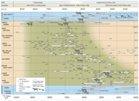
Radiocarbon dates from early and mid-Holocene occupation sites in the Eastern Sahara. The graph is arranged from north to south and based on almost 500 radiometric results from our excavations of non-oasis prehistoric sites, with condensed chronologies for the Egyptian sites of Jebel Nabta and Bir Kiseiba (4), and the Egyptian and Sudanese Nile valley and oases (16–18). The data show the clear trend of southward shifting occupation driven by the retreat of monsoon rainfall, and the contrasting economies in the Nile valley and the Sahara. Green shading marks humid conditions; symbols of domesticated cattle demonstrate the spread of pastoralism. See fig. S2 for details and site locations. Years B.P., years before present; Dyn., dynasty.
Phases of human occupation. Cumulative curves of the archaeological chronological data (Fig. 2) indicate four distinct occupation phases: (i) the Reoccupation phase (8500 to 7000 B.C.E.), starting with surprisingly early settlement in the Egyptian Sahara; (ii) the subsequent Formation phase (7000 to 5300 B.C.E.), ending abruptly in all areas without permanent water; (iii) the Regionalization phase (5300 to 3500 B.C.E.), featuring retreat to highland refuges with continuing rains and temporary lakes; and (iv) the Marginalization phase (3500 to 1500 B.C.E.), with only transient human activities in the Egyptian Sahara and prehistoric occupation restricted to Northern Sudan.
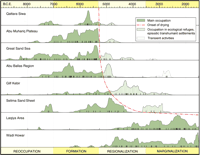
Major stages of early and mid-Holocene occupation in the Eastern Sahara based on the cumulative curves of calibrated radiocarbon dates from 150 archaeological excavations. Regions are arranged from north to south. The Reoccupation phase (8500 to 7000 B.C.E.) is characterized by early settlements in the northern regions at the beginning of the Holocene humid optimum. Major occupation continues during the Formation phase (7000 to 5300 B.C.E.) until the onset of arid conditions in the Egyptian Sahara. The Regionalization phase (5300 to 3500 B.C.E.) is characterized by the retreat of populations to ecological refuges such as the Gilf Kebir plateau, seasonal or episodic transhumance, and a marked migration into the Sudanese Sahara. During the Marginalization phase (3500 to 1500 B.C.E.), Southwest Egypt receives only passing visits while prehistoric occupation in Northern Sudan persists until the end of humid conditions at 1500 B.C.E.
Here, we discuss these major occupation phases in the context of their assumed environmental settings. We provide the climatic background in synoptic zones, limited by best estimate isohyets (lines of equal annual precipitation) on the basis of geological, archaeozoological, and archaeobotanical data (7, 9–12, 19). Correlation between the proposed pluviometric pattern and the archaeological evidence produces a coherent scenario for environmental, sociocultural, and economic change in the Eastern Sahara since the terminal Pleistocene.
At that time, the Saharan desert extended about 400 km farther south than it does today, covering more than one-third of the African continent (Fig. 3A and fig. S2A). Prehistoric sites along the Nile are overrepresented at Lake Nubia (because of the archaeological rescue missions related to the Aswan high dam) but contrast clearly with the complete lack of evidence from the desert. During the terminal Pleistocene “Wild Nile” stage at about 12,000 B.C.E (20), living conditions along the river became harsh and caused conflicts for land and food, as indicated, for example, by the late Paleolithic Nubian cemetery of Jebel Sahaba, in which many of the buried individuals died a violent death (21).
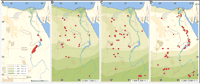
Climate-controlled occupation in the Eastern Sahara during the main phases of the Holocene. Red dots indicate major occupation areas; white dots indicate isolated settlements in ecological refuges and episodic transhumance. Rainfall zones are delimited by best estimate isohyets on the basis of geological, archaeozoological, and archaeobotanical data. (A) During the Last Glacial Maximum and the terminal Pleistocene (20,000 to 8500 B.C.E.), the Saharan desert was void of any settlement outside of the Nile valley and extended about 400 km farther south than it does today. (B) With the abrupt arrival of monsoon rains at 8500 B.C.E., the hyper-arid desert was replaced by savannah-like environments and swiftly inhabited by prehistoric settlers. During the early Holocene humid optimum, the southern Sahara and the Nile valley apparently were too moist and hazardous for appreciable human occupation. (C) After 7000 B.C.E., human settlement became well established all over the Eastern Sahara, fostering the development of cattle pastoralism. (D) Retreating monsoonal rains caused the onset of desiccation of the Egyptian Sahara at 5300 B.C.E. Prehistoric populations were forced to the Nile valley or ecological refuges and forced to exodus into the Sudanese Sahara where rainfall and surface water were still sufficient. The return of full desert conditions all over Egypt at about 3500 B.C.E. coincided with the initial stages of pharaonic civilization in the Nile valley.
Early Holocene reoccupation (8500 to 7000 B.C.E.). With the rapid arrival of monsoon rains at 8500 B.C.E., savannah-like environments turned the Eastern Sahara into a habitable region, and prehistoric humans soon settled there (Fig. 3B and fig. S2B). Groups from the south, already adapted to savannah ecology, extended their traditional way of life following the northward shifting rains, whereas Nile dwellers may have left the inhospitable valley. The epipaleolithic tool kit, as well as archaeozoological evidence from Nabta and Kiseiba, defines them as hunter-gatherers, possibly already practicing some animal husbandry (4). While this pastro-foraging economy needs further confirmation, “wavy line” decorated pottery—the first ceramics in the Old World—is a key African achievement of the ninth millennium B.C.E. (22).
Epipaleolithic camp sites in the Regenfeld area dated to 8000 to 7000 B.C.E. demonstrate quick migration of populations over several hundreds of kilometers into the central Great Sand Sea, where they encountered satisfactory living conditions in what is today the Libyan Desert's most barren part (23). Rains had turned the late Pleistocene dunes into pasture that provided wild grains for the hunter-gatherers and browsing for their game. Most notable is the almost complete lack of settlements in the Egyptian Nile valley, with the exception of El Kab (24). The dearth of archaeological sites along the Nile and in the Wadi Howar region reflects conditions too marshy and hazardous for settlement. During the early Holocene humid optimum, hunters and gatherers obviously preferred the less wooded grassland farther north to the regularly flooded and densely wooded environments of the southern Sahara.
Mid-Holocene formation (7000 to 5300 B.C.E.). After 7000 B.C.E., human settlement became well established throughout the Eastern Sahara by way of economical and technological adaptations to regionally different ecological requirements (25) (Fig. 3C and fig. S2C). On the Egyptian Abu Muhariq Plateau, bifacial technology obviously rooted in the Levant caused a complete change in the lithic tool kit that can be traced into the later predynastic cultures of the Nile valley (26). Impression-decorated pottery of Sudan tradition, on the other hand, is represented as far north as the Egyptian oases and the Great Sand Sea (27). The most important achievement of this phase is the introduction of domestic livestock. Sheep and goats, for which an early record also exists in Egypt's Eastern Desert (28), must have been introduced from their wild progenitors in western Asia (29), whereas cattle appear to have been domesticated locally. Livestock keeping, well documented at Nabta Playa (4), for example, became an essential component of a multi-resource pastoral economy that marks the beginning of African pastoral societies. Depending on local factors, their economic base differed substantially. In the western Abu Ballas area (Mudpans site 85/56), for example, rich faunal material from about 6400 B.C.E. did not reveal any evidence of domestic livestock (30), whereas in the eastern part (Eastpans site 96/2) cattle are well documented, together with a new type of undecorated late Neolithic pottery (25).
The radiocarbon dates do not indicate any rupture in regional climatic development between 7000 and 5300 B.C.E. The disparity in ceramics and lithic artifacts at Djara and Mudpans at 6000 B.C.E. suggests a break between two phases (“A” and “B”), which coincides with the arrival of sheep and goats (26). Some cultural changes may consequently have occurred beyond climate control.
According to the deficiency of occupation sites, regular monsoonal rains have ceased to reach the Egyptian Sahara not later than 5300 B.C.E. At Djara and on the Abu Muhariq Plateau there is a substantial decline in radiocarbon dates (25). Another abrupt end of occupation is observed in the central Great Sand Sea, whereas the few younger dates from Abu Minqar may be linked to local springs and transhumance from the oases depression (27). A comparable pattern of seminomadic occupation underlies the evidence for cattle at Eastpans 96/2, when living conditions in the more distant parts of the Abu Ballas region had already deteriorated. With the end of the Formation phase at 5300 B.C.E., multi-resource pastoralism appears to have become the vital human subsistence strategy in the Egyptian Sahara while at the same time the first farming communities developed in the Fayum.
Mid-Holocene regionalization (5300 to 3500 B.C.E.). The retreat from desiccating regions into ecological niches such as the Gilf Kebir and the beginning exodus to the Sudanese plains, where rainfall and surface water were still sufficient (Fig. 3D and fig. S2D), fostered more regionally diverse sociocultural adaptations. The few dates from the western fringes of the Great Sand Sea, the Abu Ballas area, and the Abu Muhariq Plateau reflect only sporadic occupation, whereas the eastern Abu Minqar and Abu Ballas areas lie within the range of transhumance from the Farafra and Dakhla oases. Certain ceramic traditions that originated in the Gilf Kebir later occurred in the Laqiya region of Northern Sudan (27), where progressive southward movement is reflected, for example, by the distribution of distinct grinding implements (30). The previously ubiquitous “wavy line” pottery is replaced by more local pottery styles. Of particular importance is the rise of specialized cattle pastoralism (4, 31), which later became a basic way of life throughout sub-Saharan Africa. This Saharan path to a productive economy was a specific African variant of a crucial change in human evolution, contrasting with the traditional Near East model of Neolithization. In place of the transition from nomadic hunter-gatherers to sedentary, pottery-producing farmers and livestock keepers, evidence suggests that largely sedentary and pottery-producing hunters, fishers, and gatherers became nomadic cattle herders. Cereal farming does not seem to have been a constituent of this Saharan “Neolithic revolution,” given that the mid-Holocene savannah still provided sufficient wild-growing grains, fruits, and tubers.
Paradoxically, in certain landscapes the decreasing trend in annual precipitation may have been associated with an increase in the vegetation cover because of a change in seasonality. Geoarchaeological evidence from the Gilf Kebir suggests that the intense daytime summer monsoon rains of the early Holocene pluvial resulted in less grass growth than the quantitatively lesser winter rains of the terminal humid phase, which presumably fell at night (32). These favorable circumstances may have maintained the rich culture of cattle keepers depicted in the rock art of the Jebel Ouenat and Gilf Kebir.
The large-scale exodus from the Egyptian Sahara coincides with the rise of sedentary life along the Nile. The first Neolithic communities in Fayum and Merimde, starting around 5000 B.C.E. with already fully developed cultivation of wheat and barley, are clearly rooted in Near East traditions. At the same time, essential social and cognitive aspects can be traced back to Saharan cattle herders and their spiritual heritage. Neolithic settlements of the Badari culture in the Nile valley recall African livestock enclosures and suggest a rather mobile existence (33). The practice of cattle burials is a presumably religious custom that has been recorded in the Egyptian Sahara from the fifth millennium B.C.E. (4). Saharan traditions of cattle pastoralism have thus become an essential component of Neolithic life in the Nile valley.
Late Holocene marginalization (3500 to 1500 B.C.E.). After 3500 B.C.E., rains ceased even in ecological niches such as the Gilf Kebir, and permanent occupation was restricted to southern areas such as Laqiya (34) and Wadi Howar in Northern Sudan (fig. S2E). For the pharaonic empire, well established after 3000 B.C.E., the Western Desert obviously played a marginal role. Generally considered a “country of evil and death,” it was thought to bar the Egyptian Nile valley from the Sudanese Sahara, where cattle herders still practiced their Neolithic lifestyle. Sporadic finds of Egyptian pottery near Laqiya (27) support rare historical reports about desert journeys during the sixth Dynasty that were considered as daring advances into the unknown.
Recent discoveries, however, shed new light on pharaonic activities in the Egyptian Sahara. Besides an elaborate desert station of King Khufu, the builder of the great pyramid, 30 outposts between Dakhla and the Gilf Kebir indicate the first trans-Saharan trail into the interior continent (35–37). At first related to Ain Azil, Ancient Egypt's westernmost town in Dakhla (38), and then throughout dynastic times, these desert stations indicate watch-posts concerned with prospecting or trading, or the prevention of smuggling, of African goods to the Nile valley. Because the camel was introduced to Africa only during the first millennium B.C.E., any long-distance travel through waterless desert had to rely on donkeys. Their water needs required extraordinary logistical skills and geographical knowledge—an example of how early societies coped with the challenges of hyper-arid environments.
Conclusions. Whereas earlier studies have dealt with the response of discrete cultures to climate changes in distant regions during different periods (39, 40), we present here a consistent model of how past climate changes, over a coherent region of subcontinental scale, have affected human societies throughout the Holocene. Contrary to inferences from offshore marine sediment records and numeric modeling (41, 42), the only supraregional climate signal in the geological and archaeological archives of the Eastern Sahara is the onset of semi-arid conditions in the north and semihumid conditions in the south at about 8500 B.C.E. Within only a few centuries, the desert margin shifted up to 800 km north to latitude 24°N, bringing monsoonal rainfall to most of the former desert. Taking into account the west east gradient of decreasing humidity from the Atlantic Ocean to the Red Sea, this process apparently applied to the entire Sahara.
This fundamental climatic change from terminal Pleistocene hyper-arid desert conditions to savannah-type vegetation and the formation of lakes and temporary rivers resulted in the rapid dissemination of wild fauna and the swift reoccupation of the entire Eastern Sahara by prehistoric populations. Relatively stable humid conditions prevailed over approximately the next 3200 calendar years between 8500 and 5300 B.C.E. Abrupt drying events stated elsewhere in the Sahara may be explained by fading rainfall at a specific latitudinal position at a certain moment, or by dropping local groundwater.
The roughly parallel southward shift of monsoonal precipitation that set in at 5300 B.C.E. can be tracked through the following millennia by the discontinuance of the sedimentary record of aquatic deposits at decreasing latitudes. The geological archives in agreement with the archaeological evidence indicate a gradual desiccation and environmental deterioration of the Eastern Sahara, notwithstanding transitory climatic perturbations that are a common feature of all desert margins. This rather linear process culminates in the present extremely arid conditions, which have not yet reached the extent of the terminal Pleistocene (fig. S2F).
The southward movement of human settlement implied substantial changes in the pattern of behavior and land use as response to regional environmental differences. Most of all, mobility was the key to survival; it has driven prehistoric societies from foraging to a multi-resource economy and specialized pastoralism. The final desiccation of the Egyptian Sahara also had an essential impact on the contemporaneous origin of the pharaonic civilization in the Nile valley. To this day, conflicts in sub-Saharan regions such as Darfur are rooted in environmental deterioration, aggravated by severe demographic growth and man-made desertification. The presented data and conclusions suggest that the climate-controlled desiccation and expansion of the Saharan desert since the mid-Holocene may ultimately be considered a motor of Africa's evolution up to modern times.
Supporting Online Material
www.sciencemag.org/cgi/content/full/1130989/DC1
Materials and Methods
Figs. S1 and S2
Table S1
References
- Received for publication 7 June 2006.
- Accepted for publication 12 July 2006.